Maps for Outdoor
Apple Watch is for outdoor activities and sport. There is no doubt that all the sensors, the excellent GPS, and the many applications available on the App Store are the sing that a large fraction of the users use it for sport and outdoor activities, and I am one of them. Then I spent couple of days reviewing some app especially for maps because I hike and to have an additional device with maps can be very useful, especially if it is on my wrist. As usual I looked for something that is independent from the iPhone, if it can works completely offline (on mountains there is no LTE signal most of the time) is even better.
WorkOutDoors
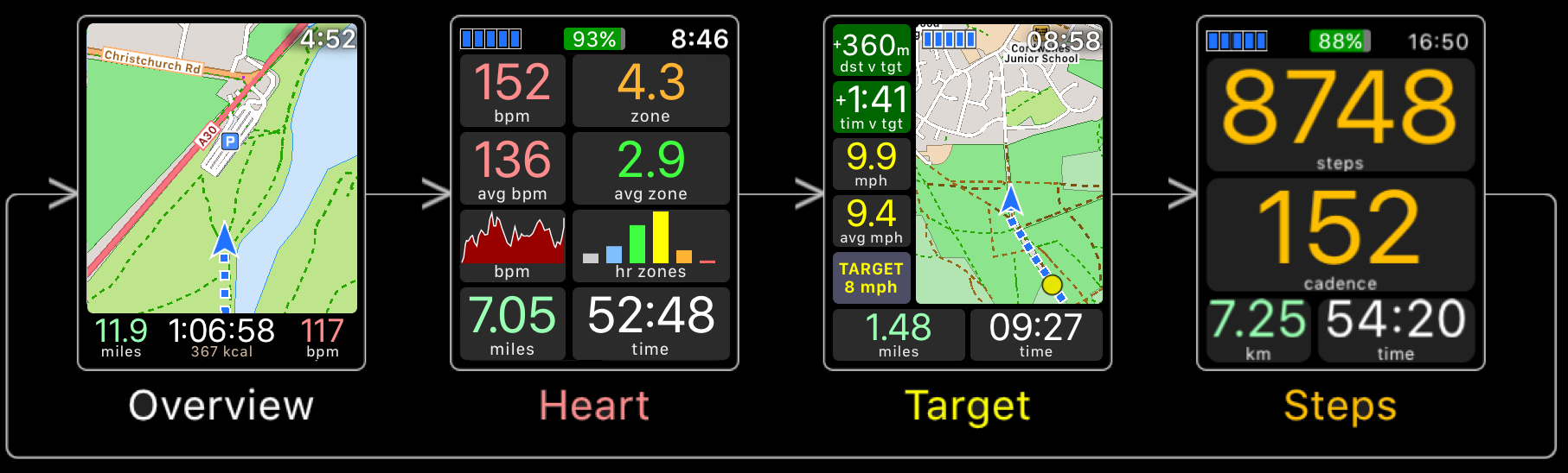
This is the app for outdoor. It is the only one that I found where the map is loaded immediately in LTE with no need of the phone. It allows to visualize only a map without tracking an activity as well as to record your workout with a large library of possible workouts. For each activity there are four informative screens infinitely customizable (ok, not really infinitely, but I think in mode than 500 possible ways).
The maps are vectorials from Openstreetmaps, this means that the map loads in a second and the browsing is very fast. From the iPhone is possible to select an area to download to have it offline on the Watch later, so even without LTE is possible to browse the map without the iPhone.
This app costs $5.99 but its real value is much higher than that. The only drawback for me is the lack of topographic maps. I contacted the developer to discuss this issue and he told me that the services that provide topo maps are never for free, so he should switch (or add) a subscription model to pay the costs of the service. I think that I would buy a subscription if the quality of the topo maps is the same as the one of the current map, but I can understand that the occasional runner may not want to pay for it. Anyway it seems that many people requested this feature and the developer is working to an upgrade. I will update this post if there are news.
Gaia GPS
The reason why I mention Gaia GPS is not exactly for its Apple Watch app. The application is the reference for anyone that wants to do a serious outdoor activity. It is undisputably the best app for maps available on the market with multiple layers on maps and an accuracy in the information that is of another level compared to the other maps.
But the Apple Watch app that they provide is crap. Basically is a companion app for the iPhone, you need to have it with you and every time you open the app on the Watch it opens the map on the phone. The result is double usage of battery. Moreover the visualization of the map is very slow on the watch, and the navigation is sloppy.
So why do I talk about Gaia GPS? Because I reported these issues to their customer care and they answered me that a new Apple Watch app is under development with a stand-alone navigation (no iPhone needed) and better performances. In practice I leave this post as a placeholder hoping that the dream of having Gaia GPS on the Watch comes true. Stay tuned.
Other Maps
Along this research I tried the most popular maps with an Apple Watch integration. I can mention Viewranger, Maps 3D PRO - Outdoor GPS and Topo Maps+. My experience with these maps is not great. It is clear that the Watch app is a companion of the main app for iPhone and was not created having in mind the Apple Watch. The loading is in general slow, and for most of them (I tried several other minor maps) the app is just a secondary screen for the iPhone, not something that you can use leaving your iPhone at home (or switched off in your backpack).
Only Viewranger offers the possibility to download the maps offline and use with no signal, that is very good when you are off the grid, but the overall usability is not excellent and you cannot load the maps with LTE if you are connected, so you need to prepare everything in advance.
Of course I haven’t mentioned here the Apple Maps (neither the Google Maps), because the main goal was a map for outdoor and those maps are not great when you need to know the path of your trail, but for a generic use those maps are excellent as on the phone and work without the need of the iPhone with you.